Important NotificationMake sure to get installed the
confirmed planes before hand, to avoid delays or yellow gliders
 USA TOUR event | 25th Leg: Pago Pago - American Samoa | Military Long Range | SAT AUG 30TH 05:00 - 19:00 UTCTWENTYFIFTH TRIP
Departing Kansas City International Airport,
(KMCI): Kansas City - Missouri Arriving Pago Pago International Airport,
(NSTU): Tafuna, Pago Pago - American Samoa ***************************************************************************
Leg Distance:
approx 5400 nm Competing Aircraft:
Any Long Range Military Aircraft
capable of keeping cruise conditions for at least 6000 nm (by Specs)Expected Cruising Speed:
260 KIAS | 0.75 Ma | 434 KTAS Expected Cruising Altitude:
FL320-FL360/Even Expected Duration (en route):
12 hours 35 minutes****************************************************************************
Flightgear's USA Tour 25th: Military Long RangeRecently USA tour arrived to Kansas City in the State of Missouri (yes, not Kansas). We did so using Cargo Propeller planes in an amazing trip that looked neat and traffic remained really organized. The props cargo planes also looked amazing.
USA Tour 25th Map

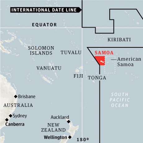
The next 25th leg will take USA tour back to the farthest regions of the globe. As a matter of fact, we are now heading to an extreme location in the middle of the Pacific Ocean: American Samoa. This destination is so extreme, that it is, actually the Southern-most and at the same time the Western-most USA Tour hub. As a matter of fact, it is located a few miles of the International Date Line:
American Samoa is a World's Westernmost Location
The longest routes for the USA tour present a complex situation. In particular, it is not feasible to do this long hauls in short times, tipically, and thus event duration is lengthened, sometimes considerably. Last time we dared to the far pacific, we arrived the island of Guam. We travelled there in a long-haul that lasted the not small time of 15 hours, and the trip was flown using Civilian Long-range Airlines (I used, particularly the A380). Now, a new Long-Range event is taking place, but this time the twist is that Military Aircraft will be used instead. Any category, bombers, cargo, figther, recognition, refuel, etc, but the Aircraft needs to have been used for Military Purposes, and at the same time, be range and cruising conditions capable.
Another twist this time is that the flight is actually a "red-eye" flight. Occurring on its totality during night time (local times). We will be departing KMCI at Midnight (in Kansas City), and we will be arriving American Samoa around 6:30 AM local time. That same day, sunrise will occur at exactly 06:29AM in this location, which means, exactly our arrival will occur at sunrise, and we will be landing a few minutes after the star shows up in the horizon on AUG SAT 30th. After flying for over 12 hours, the effective time of flight will be around 7 hours.[from Midnigth to 7 AM on Saturday].
Naturally, to be able to understand the ACTUAL time this event is happening we will maintain UTC reference. Departure is occuring on SAT AUG 30TH at 05:00UTC from KMCI, and Arrival is scheduled to occur on SAT AUG 30TH at 17:30 UTC. Event duration may last until approximately 19:00 UTC. This may be an overnight flight, or a full-day flight for you depending on your location. To have a sense of what local time this event is happening in your area, you may refer to the following chart.
USA Tour 25th TimeLine
 Aircrafts
Participant planes had to comply with
- Being a military aircraft, or having been used for Military in any category (transport, fueling, bombing fighter, etc).
- OR Aircraft that are tipically Civilian ARE ACCEPTABLE if these had been acquired and used for military purposes. Examples of this may include A330, B747(ie, Airforce One), B777, and others
- The Aircraft will have an unrefueled range published of at least 6000 nm. Pay attention to Ferry Ranges in oppose to Combat Ranges.
- The Aircraft will be able to maintain reasonably the expected cruising conditions, with a ceiling higher than FL320 and able to maintain 0.75 Ma speed.
I will place a list of confirmed planes below
The GCMAP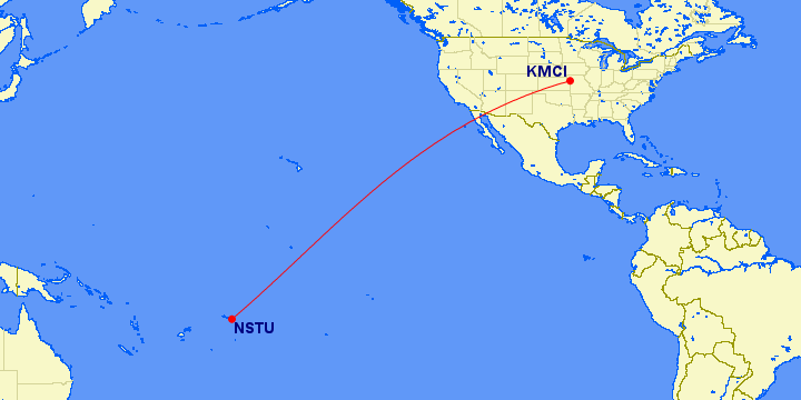
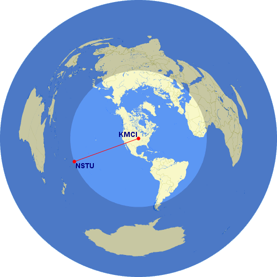 Note: In the map above, the lighter circle represents area that is closer to KMCI than NSTURoute
We will be following an RNAV route.
SKYVECTOR:
Code: Select all
KMCI WLDCT3.SLN MCI(113.25) TYTUS KENTN SLN(117.1) PENUT EDARE ZIGEE FORUN BUKEE GIREY NIDSE CUVEK OCURO STEPN MALIT IGOTT FICKY AHNDO BELAN CANOL SANTA QUIGG PASSA SAPIX DARMA JONAS DRAWN TUT(112.5) NSTU
 PROCEDURES
The following are important proccedure information.
Ground ChartsSIDsIAPsExpect arriving and holding JONAS@3000ft, then clearance to land ILS RWY 05 or DME/TACANB RWY 23 if conditions require.
CommunicationsCommunications will take place with mumble. Important messages can be relayed on FGChat.
Sincere thanks to Michat for offering the intercom room and channels. This will be located in the FG mumble server:
Code: Select all
server: mumble.allfex.org
Room: USA Tour
To install and prepare the mumble (any OS), see here:
http://mumble.sourceforge.net/Main_Page